Historical perspective of sea level changes
Robert Endlich:
Seas have been rising and falling for thousands of years – without help from the EPA or IPCC.This is a history the warmist ignore because it does not fit their agenda of crating hysteria to stampede people into to going along with control freak government solutions that give them more power. They are seeking totalitarian solutions to a problem that largely exist only in their minds.
...
Sea level changes over relatively recent geologic and human history demonstrate that alarmist claims do not withstand scrutiny. Sea levels rose significantly after the last ice age, fell during the Little Ice Age, and have been rising again since the LIA ended around 1850. In fact, Roman Empire and Medieval port cities are now miles from the Mediterranean, because sea levels actually fell during the Little Ice Age.
During the deepest part of the last ice age, known as the Wisconsin, sea levels were about 400 feet lower than at present. As Earth emerged from the Wisconsin some 18,000 years ago and the massive ice sheets started to melt, sea levels began rising. Rapid sea level rise during the “meltwater pulse phase,” about 15,000 years ago, was roughly five meters (16 feet) per century – but then slowed significantly since the Holocene Climate Optimum, about 8,000 years ago.
Those rising oceans created new ports for Greek and Roman naval and trade vessels. But today many of those structures and ruins are inland, out in the open, making them popular tourist destinations. How did that happen? The Little Ice Age once again turned substantial ocean water into ice, lowering sea levels, and leaving former ports stranded. Not enough ice has melted since 1850 to make them harbors again.
The ancient city of Ephesus was an important port city and commercial hub from the Bronze Age to the Minoan Warm period, and continuing through the Roman Empire. An historic map shows its location right on the sea. But today, in modern-day Turkey, Ephesus is 5 km from the Mediterranean. Some historians erroneously claim “river silting” caused the change, but the real “culprit” was sea level change.
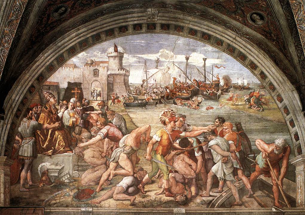
Ruins of the old Roman port Ostia Antica, are extremely well preserved – with intact frescoes, maps and plans. Maps from the time show the port located at the mouth of the Tiber River, where it emptied into the Tyrrhenian Sea. The Battle of Ostia in 849, depicted in a painting attributed to Raphael, shows sea level high enough for warships to assemble at the mouth of the Tiber. However, today this modern-day tourist destination is two miles up-river from the mouth of the Tiber. Sea level was significantly higher in the Roman Warm Period than today.
An important turning point in British history occurred in 1066, when William the Conqueror defeated King Harold II at the Battle of Hastings. Less well-known is that, when William landed, he occupied an old Roman fort now known as Pevensey Castle, which at the time was located on a small island in a harbor on England’s south coast. A draw bridge connected it to the mainland. Pevensey is infamous because unfortunate prisoners were thrown into this “Sea Gate,” so that their bodies would be washed away by the tide. Pevensey Castle is now a mile from the coast – further proof of a much higher sea level fewer than 1000 years ago.
Before modern Italy, the region was dominated by the famous City States of the Mediterranean, among which is Pisa, with its picturesque Cathedral Square and famous Leaning Tower. Located near the mouth of the Arno River, Pisa was a powerful city, because maritime trade brought goods from sailing ships right into the port. Its reign ended after 1300 AD, the onset of the Little Ice Age, when sea levels fell and ships could no longer sail to her port. Once again, some say “river silting” was the cause.
However, Pisa is now seven miles from the Tyrrhenian Sea, with large meanders upstream from Pisa and little meandering downstream. When a river is “at grade,” the downstream gradient is as low as possible, as with the meandering Mississippi River and delta in Louisiana. Rivers with a strong downstream gradient flow to the sea in a direct route, with few meanders, as with the Rio Grande in New Mexico.
...
Comments
Post a Comment